
Resultados: visualización detallada
Registro 6 de 6.480 para la búsqueda


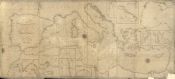
A new and improved chart of the Mediterranean Sea including the coast of Spain and Portugal / the lastest authorities by Robert Blachford
- Tipo de Documento Material cartográfico impreso
- Materia Cartas náuticas - Mar Mediterráneo
-
Descripción física
1 mapa : blanco y negro ; 79 x 178 cm.
-
Descripción
Inserto de: Port of Genoa - Harbour of Toulon - Leghorn Road - Alicant Bay - Straits ...Inserto de: Port of Genoa - Harbour of Toulon - Leghorn Road - Alicant Bay - Straits of Messina - Malta and Gozzo - Passage of Dardanells - Gulf of Smyrna."Engraved by S. Stockley" - Mapa.
Disponible en formato digital.
Reproducción electrónica. - Identificador BNC01000000000000001124494


