
Resultados: visualización detallada
Registro 38 de 8.666 para la búsqueda Institución Biblioteca Nacional de Argentina


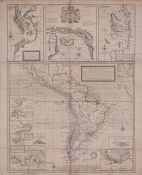
A new & exact Map of the Coast Countries and Islands within ye limits of ye South sea Company, from y River Aranoca to Terra del Fuego, and from thence through ye South Sea, of ye North Part of California &c. with a view of the General and Coasting Trade
winds and erticular Draughts of the most important Bays, Ports &c. According to ye Newest Observations / by Herman Moll geographer
Moll, Herman (1654?-1732)
1720
- Lugar de publicación Londres]
- Datos de edición [Londres] : sold by H. Moll, [1720?]
- Tipo de Documento Material cartográfico impreso
-
Materia
Cartografía inglesa - Siglo XVIII - Mapas
América del Sur - Siglo XVIII - Mapas
Mapas antiguos - América del Sur - Siglo XVIII
Cartas náuticas - América del Sur - Siglo XIIII -
Descripción física
4 mapas en 1 pliego : grab., col ; 42 x 49 cm. sobre pliego 68 x 56 cm.
-
Descripción
Márgenes graduados. Relieve por montes de perfil y sombreado. Abundante toponimia. Red hidrográfica. Poblaciones autóctonas.
Meridiano de origen : 60 grados al oeste de Londres.
Orientado con dos rosas con lis de 8 vientos.
En la parte superior izquierda del mapa principal : "A map of ye Port of Baldivia with the Fortifications and Islands &c. done after a new spanish Draught". 22 x 14 cm. Orientado con rosa con lis de 8 vientos.
En la parte superior central del mapa principal : "Part of Peru". Orientado con rosa con lis a la izquierda de 8 vientos. En el centro superior del mapa, en cartela moldurada con escudo con ángeles, la leyenda : "To the Hom.ble Robert Earl of Oxford & Mortimor &c. This map & sea - Draughts is most Hom.ble dedicated by H. Moll".
En la parte superior derecha del mapa principal : "A Map of Chiloe. The Lake of Acuna, with the Islands &c. done after the newest spanish draughts". Escala [ca. 1:2.677.000]. 22 x 14 cm. Orientado con rosa lisa de 8 vientos.
Con varios mapas insertos : A chart from England to the River Aranoca &c. - Peypses of Pepys I. - A Map of ye Straits &c - The port of Acapulco ...Con varios mapas insertos : A chart from England to the River Aranoca &c. - Peypses of Pepys I. - A Map of ye Straits &c - The port of Acapulco - The Gulf of Amapalla or Fonseca - The Gulf of Niya or Gulf of Salinas - The Gallapagos Islands - The Island of Juan Ferdinando - A Map of the Isthmus of Darien the Bay of Panama &c.Disponible en formato digital (BNA_MA010602). - Identificador 001309811
-
CDU
912 (8)
912 (72/729)


